

 Cover image via
Follow us on Instagram, TikTok, and WhatsApp for the latest stories and breaking news.
Malaysia has been experiencing heavy rainfall for the past few days, triggering flash floods in Kelantan, Perlis, Perak, Selangor, and beyond
If you have been following weather alerts issued by the Malaysian Meteorological Department (METMalaysia), you may have noticed two common types: amaran hujan berterusan (continuous rain warnings) and amaran ribut petir (thunderstorm warnings).
But what do these warnings actually mean? How are they different? And at what point does rainfall become dangerous?
As of yesterday, 24 November, Saujana Aman, Bukit Antarabangsa, Sungai Air Tawar, Elmina Farm, and Paya Jaras Hilir in Selangor are some of the areas with over 100mm of rainfall. But what does this measurement actually indicate?
To understand this, let's explore METMalaysia's directory and other governmental sources to break down the terms and metrics used in rain-related weather reports, helping you better understand weather alerts.
Here are the differences between continuous rain warnings and thunderstorm warnings
Continuous rain warnings
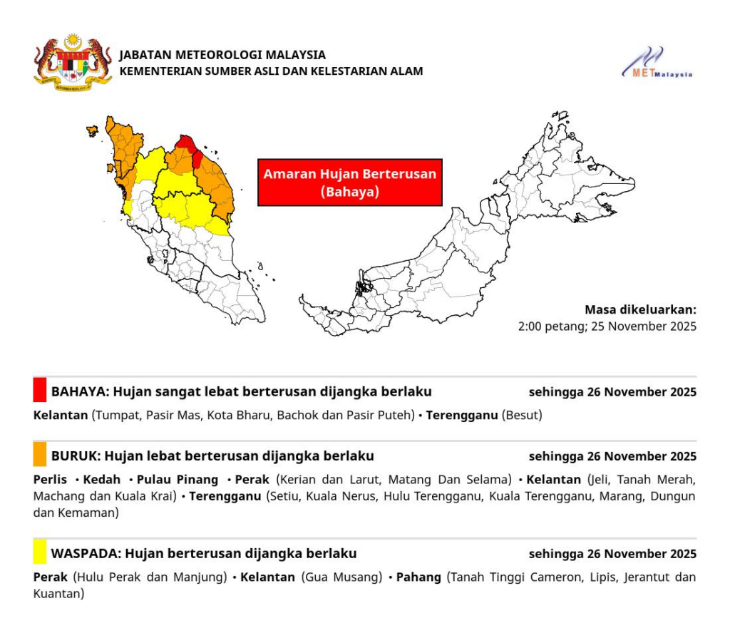
This type of warning applies to weather forecasts for the next one to three days. METMalaysia will always indicate the duration of the alert or update it when new information becomes available.
This alert comes in three warning levels: Waspada (Beware, yellow), Buruk (Bad, orange), and Bahaya (Danger, red). Here are the definitions provided by the department:
• Waspada (Beware, yellow): Continuous rain is expected to begin in the next one to three days, or the ongoing rain/thunderstorm is expected to continue
• Buruk (Bad, orange): Continued heavy rain is expected
• Bahaya (Danger, red): Continuous very heavy rain is expected
Thunderstorm warnings
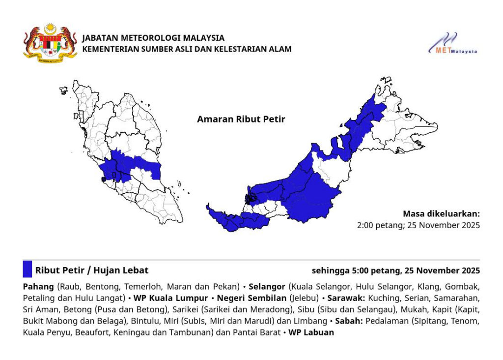
This type of warning is issued when there are clear indications from meteorological station observations, radar echoes, satellite imagery, Numerical Weather Prediction (NWP) products, and upper air charts showing thunderstorms with rainfall intensity exceeding 20mm per hour, either occurring or expected to occur.
A thunderstorm warning is a short-term alert that is valid for no more than six hours per issuance.
A thunderstorm event is associated with the presence of lightning and thunder resulting from the formation of cumulonimbus clouds. Thunderstorms are usually accompanied by strong winds and heavy rain over a short period, which can cause flash floods.
In extreme situations, thunderstorms may also produce hail and tornadoes (water spouts and land spouts).
What does 20mm per hour of rainfall mean?
According to the World Meteorological Organization (WMO), rainfall intensity is measured in millimetres per hour (mm/h).
Here is what you can expect at different rainfall intensities based on InfoBanjir JPS (Department of Irrigation and Drainage) Selangor standards:
| Category | Rainfall Amount (per hour) | Description |
|---|---|---|
| Light | 1 – 10 mm | Standard rain, usually no immediate flooding risk. |
| Moderate | 11 – 30 mm | Noticeably heavier; visibility drops. |
| Heavy | 31 – 60 mm | Very intense rain; high risk of flash floods in urban areas. |
| Very Heavy | > 60 mm | Extreme downpour; dangerous driving conditions and high flood risk. |
Convective rain exceeding 60mm within two to four hours can typically cause flash floods. However, monsoon rain is usually prolonged with intermittent heavy downpours, and its intensity can occasionally surpass several hundred millimetres in 24 hours.
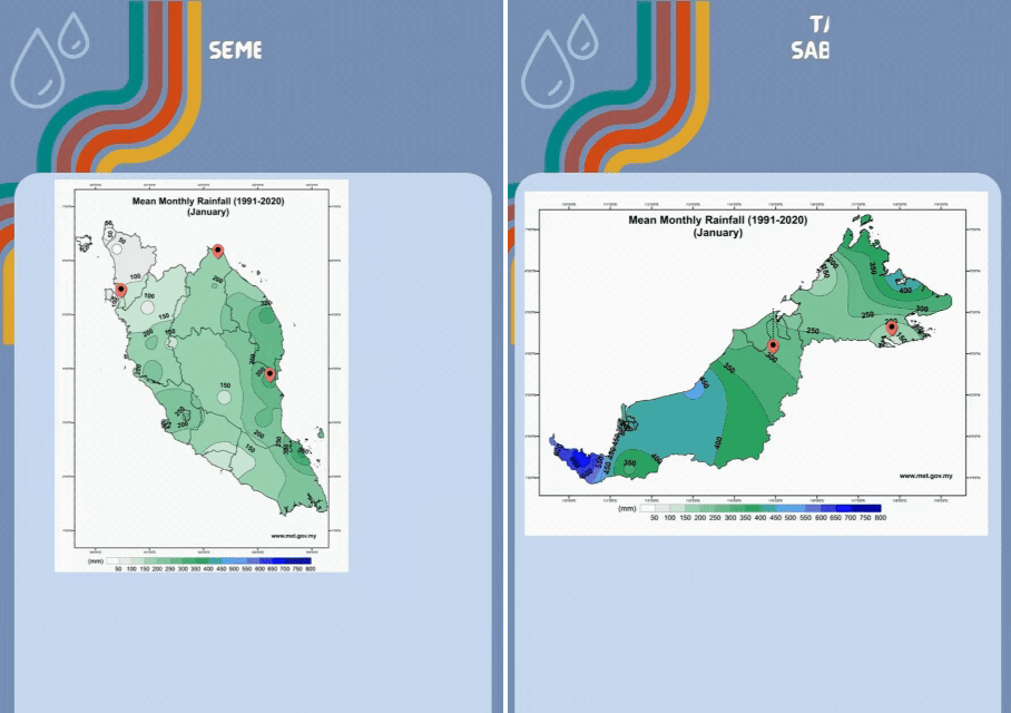
According to METMalaysia, rainfall distribution in West Malaysia is between 1,800mm and 3,500mm, and 1,500mm and 4,000mm for East Malaysia in general.
Rainfall distribution is low in the north between January and February, and high on the east coast between November and December for West Malaysia.
The GIF below illustrates the mean monthly rainfall across Malaysia, with different colours representing rainfall intensity (light green for low, dark blue for high) across the months:
To know which area in the Klang Valley has a rainfall of over 100mm and beyond, you can visit InfoBanjir JPS Selangor's official website here.